
Graphic belongs to the National Weather Service
With the weather becoming significantly colder next week, the National Weather Service identifies the contributing factors.
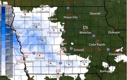
Meteorologist Donna Dubberke tells Raccoon Valley Radio that there is a large area of cold air moving down to central Iowa from the north. She says that this will cause a pattern shift in the atmosphere and the state can witness snow, especially later in the week. With the elongated fog that’s been in the forecast, Dubberke describes when that will be moving out of the area.
“That is going to be pushed out by this cold air that’s coming in, and as the winds pick up and that will kind of clean things out, and we should be kind of in that blustery northwind. It will be a pretty noticeable change.”
Dubberke highlights a positive aspect about the cold front coming through is that the fog will fully disappear and bring sunny skies by the end of the week. The National Weather Service is estimating temperatures to fluctuate between 20 and 30 degrees until the weekend and early next week, when the daytime highs are in the teens.