
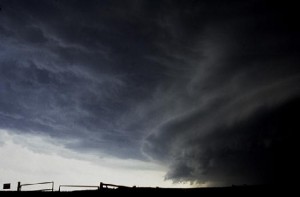
With the advancement of technology, there are lots of ways to foresee weather patterns, but an Iowa expert mentions that unpredictable circumstances still arise.
State Climatologist Justin Glisan explains that the summer is known for having what he calls “Thunderstorm Driven Precipitation Events.” He says that it’s much easier to predict when there’s a large amount of rainfall across Iowa, compared to isolated thunderstorms.
Glisan tells Raccoon Valley Radio that he analyzes thunderstorms through an eight-day convective outlook and acknowledges that it’s challenging to predict a certain time weather will hit more than five days out. However, he shares that Convecting Allowing Models can identify a severe weather event easier, but there are still obstacles that prevent themselves.
“All the ingredients are there, but you have not enough moisture in terms of the dewpoint temperature, or not enough windshear in the environment. If one or two or these components are off in a mish-mash of things that you need to come together to produce severe weather, it can be a bust in terms of that forecast.”
Glisan notes that there is a shortage of employees at National Weather Service offices and that there’s less model data resulting in an uncertainty to properly predict weather conditions. He details that a hurricane and snowstorm are the two hardest weather patterns to track, but thunderstorms are in that mix, especially during the spring and summer seasons.